I have seen old ships sail like swans asleep beyond
That village which men still call Tyre
With leaden age o'er cargoes, dipping deep
For Famagusta and the hidden sun
That rings black Cyprus with a lake of fire.
--- James Elroy Fletcher, "The Old Ships"
Look at the ships also; though they are so great
and are driven by strong winds, they are guided by a very small
rudder wherever the will of the pilot directs.
--- James 3:4, Holy Bible, Revised Standard Version
Ever since 1948, evidence that pre-Columbian Old World explorers repeatedly visited America has accumulated in my files. Naturally, the question was, "How did they arrive?" Obviously, it had to have been by sea, using ships. Many styles of graceful and splendidly built ships were used in the Old World before the time of Columbus.
Making the Crossing
Of first interest were the vessels of the Vikings, whose voyages are vividly described in the Norse Sagas, and whose New World runestones sparked my work in epigraphy. The feasibility of an Atlantic crossing in these types of vessels has been established for a century. In 1893, an exact replica of the wooden burial ship excavated at Gokstad sailed from a port near Bergen, Norway. Twenty-eight days later the ship landed in Newfoundland.
Throughout the years, as I become more involved in epigraphy, ancient Iberic, North African, Gaelic, and Celtic inscriptions were recorded in the interior of America. The ships of these people were also studied to determine their sizes, shapes, and construction methods.
Daring modern-day seamen, who also sought to show that ancient people could have crossed the Atlantic Ocean, independently came up with their own method of research. They built crafts of the same designs and materials as used by the ancients and crossed the ocean in them. In 1970 Thor Heyerdahl made his successful voyage in the papyrus boat Ra II. Timothy Severin sailed from Ireland in a 36-foot leather boat to prove that the legendary sixth century A.D. voyage of St. Brendan could have been based on fact. His replica of the saint's craft landed at Newfoundland in 1977.
It is not just reproductions of ancient vessels that have made the crossing. Dr. Alice Kehoe has stated that there are hundreds of authenticated modern crossings in small crafts of every description, including rafts, dugout canoes, dories, small sailboats, kayaks, folding boats, and an amphibious jeep. Kehoe detailed the voyage of Dr. Alain Bombard, who proved in his 1952 doctoral thesis that shipwrecked people can stay alive on products of the sea alone. Without stored food or water, taking only a small net, fishing line and hook, and a large and small harpoon, Bombard left Casablanca, Morocco, in a 15-foot rubber raft and arrived sixty-five days later at Barbados in the Caribbean.
Added to Kehoe's accounts are newspaper articles and television newscasts reporting many more voyages. In 1928 a German named E. Romer paddled from Portugal to the West Indies in a kayak. Then, in July 1979 Gerry Spies of Minnesota crossed from Virginia to Cornwall, England, in a 10-foot homemade sailboat, thus surpassing William Verity who in 1966 sailed from Fort Lauderdale, Florida, to Tralee, Ireland, using a 12-foot boat.
It was not until July 1987 that the question of the feasibility of trans-Atlantic small-craft crossings was settled beyond all doubt. A newspaper item stated that a young Frenchman, Stephanie Peyron, age twenty-six, had completed the first solo crossing on a wind surfboard. Peyron left New York City on June 10 and reached the coast of Brittany, France, after forty-six days at sea.
In 1991 a Frenchman rowed across the Pacific Ocean in a kayak. Gerard D'Aboville left Japan in July, and 134 days and 6500 miles later, landed in Washington state. His vessel was 26 feet long and made of carbon fiber. D'Aboville capsized thirty-six times during the voyage. Rowing ten hours every day, he lost thirty pounds, but his voyage was a first.
Obviously, trans-Atlantic crossings were well within the capabilities of ancient Old World mariners. Also fascinating are the accounts compiled by Dr. Vincent M. Cassidy, showing that American Indians may have landed in Europe centuries before the time of Columbus. One instance of American visitors is quoted by both of the historians Cornelius Nepos and Pliny the Elder. These visitors were supposed to have arrived in Gaul in 63 B.C. In the sixth century A.D., seven dying copper-skinned men landed in Ireland and were revived long enough to be baptized. Still more visits from American Indians are recorded through 1507 A.D. Cassidy says that while the reports are tenuous, they are well documented.
Navigating Waterways to Interior America
It appears that ocean crossings in both directions were feasible between the Old and New Worlds, both trans-Atlantic and trans-Pacific. The question of whether ancient crossings did occur is a separate issue. The inscriptions, petroglyphs, and artifacts found in the interior of America, that are discussed in this book, bear directly on this subject. Even if landings on the Atlantic Ocean seaboard did occur, this does not explain how ancient Old World visitors could have traveled into the interior of the continent to leave the evidence presented here. Somehow, when confronted with this question, most people seem to think that the Old World people must have hiked through forests, forded rivers, and crossed vast prairies, to travel halfway across the continent. But they no more needed to walk through the wilderness than they needed to swim the Atlantic Ocean. The continent was then paved with shining highways: an unpolluted river system. All the explorers would have to do was to follow the coastlines to find the mouths of rivers, both large and small. Ship pilots who rounded the Florida peninsula and entered the Gulf of Mexico would have discovered the Mississippi River, along with other smaller streams. The explorers who navigated these rivers must have left behind some evidence of their passage.
River Systems in Interior America
When ancient people traveled too far up-river to permit passage of their large, ocean-going ships, they of course knew how to build smaller boats. When rivers dwindled to streams too shallow or rapid for even small craft, ancient visitors could still walk alongside the creeks of interior America. The rivers and their tributaries were a network of unchanging pathways to the interior, allowing strangers to explore any area without becoming lost, if they would always follow the waters.
While studying the river systems of interior North America, the relationship of ancient sites to waterways was noted. It seemed that if ancient visitors used streams and rivers to explore a new continent, that the same waterways could be searched to find evidence of their visits (Fig. 2-2). Interest was focused on any river or creek that eventually drained into the Gulf of Mexico. A major river like the Arkansas, which heads in Colorado, has yielded many inscriptions on its banks and on its tributaries, many of which are discussed in other chapters. Searching along the Arkansas River has not been easy, but the Old World people left directional signs as well as their names along the way.
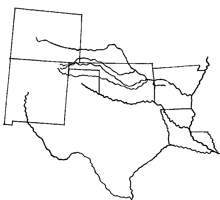
Fig. 2-2 Map of some of the rivers in south-central United States.
Short Mountain, Oklahoma, which stretches for only 2 miles along the south side of the Arkansas River, is the present location of the Kerr Lock and Dam, one of a series of structures which has restored river navigation all the way from Tulsa to New Orleans. This mountain was searched because a straight line connecting the locations of four runestones, when extended to the river, came out precisely there.
The highest point on the western end of the mountain is strewn with rough boulders. On one of these was inscribed a smooth circle 6 inches in diameter. In it was inscribed a cross. The leg which pointed upriver, to the west, had a "V"-shaped split at the end, with a cross bar.
A circular boulder is located 200 miles upstream from Short Mountain. It sits in the middle of the river and is 20 feet in diameter. If one tries to think like an ancient traveler, this would be an obvious place for an inscription. Four 10-inch symbols were found in a straight line on the boulder's top surface, 7 feet above the water line. They were very similar to symbols in various Mediterranean alphabets. The symbol nearest the water, pointing upstream, was a cross with a "V"-shaped symbol superimposed on the longest leg of the cross.
How many other plain landmarks on the Arkansas River, beginning with its confluence with the Mississippi River, to its source in the Colorado canyons, remain intact, still bearing marks made by navigators of ancient ships? Perhaps as important as the signs and actual words left by the ancient explorers on the waterways are the pictures they left us of their ships.
The Ship Petroglyphs
Evidence of the presence of ancient European and Mediterranean people in the interior of the United States is found in the numerous images of their ships incised or pecked into stone. Some of these are associated with inscriptions in Old World alphabets and languages. Most have been found on the streams and rivers that are tributaries of the Mississippi River, but some have been found elsewhere, near waterways in the Rio Grande and Colorado River systems. Still others have been found far from presently navigable rivers.
Beginning in 1973 I have recorded these beautiful ship petroglyphs. Many were found by my exploring parties, still others were contributed by friends. There is now a total of forty-eight ship images from Oklahoma, Colorado, New Mexico, Arizona, Utah and California in my files. This is probably but a small fraction of the ship petroglyphs yet to be recorded in North America.
It is remarkable that no two of the ship petroglyphs
are alike, and none are exact duplicates of Old World ships. Yet
each American petroglyph has features which may be found in some
Old World counterpart. Some of the ship petroglyphs and similar
images from the Old World are presented. These comparisons are
not to be taken to mean that the people who made the two images,
an ocean apart, came from the same culture and time. The development
of the Old World ships was gradual, and certain maritime features
were shared among different cultures, or are common in ships from
different periods. However, some of the comparisons are striking,
and the American ship petroglyphs almost speak for themselves.
Six of the ships are shown in other chapters and twenty-four are
described here.
The Rebus Ship
The greatest thrill of discovery is usually when you find the first of something. The first ship petroglyph was found on July 12, 1973, in Picture Canyon, Colorado, near the Oklahoma border. It was almost missed, as it was pecked on the slanting underside of a boulder. It is probably the most distinctive of the ship petroglyphs because it is made of ancient script in the form of a rebus. The type of rebus encountered in Colorado is a drawing of an object made up of the letters that spell the word for the object. The letters are also arranged in the exact order needed to spell the word. Let's look at an example of how a rebus could be made.
Suppose you applied for a job and were told that you needed to take a test to rate your ability to combine mental images with linguistic and practical applications. When you consented, the instructor gave you an alphabet of cut-out wooden letters and explained that you should arrange any number of them in such a way that it would make a picture of something.
You decided to make a picture of a chicken. You selected an "I" for a bill, an "O" for a head, an "L" for a neck, a "K" for legs, a "D" for a wing, and another "K" for tail feathers. Then you laid these letters out in what you thought was a pretty good portrayal of a chicken (Fig. 2-3). The instructor said yes, you got the idea, but next you had to repeat the task, but this time only using the letters that actually spell "chicken." Furthermore, the letters must be arranged in the order in which they occur in the word.
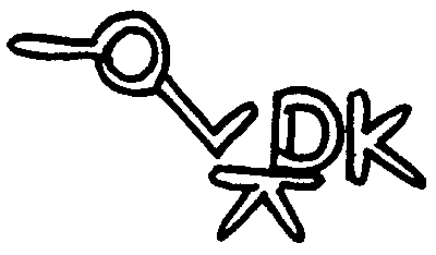
Fig. 2-3 Example of the construction of a chicken rebus using any letters.
That sounded rather difficult, so you asked if you could do it with a pencil and paper, in order to make some letters large and some smaller and curve some lines a little, and you were given permission. So this time you ended with a bird-like form, except that it had no bill (Fig. 2-4). You concluded that it would be impossible to observe all limitations and still make the drawing look exactly like a chicken. You also concluded that the same problems would apply to making any rebus.
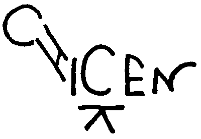
Fig. 2-4 Chicken rebus using letters in order in the word "chicken."
Despite the difficulty involved, a friend invented
an English rebus for "BOAT."(Fig. 2-5). It shows
a boat with an upcurved prow, a square stern, a rudder, and a
small mast or flag-staff with cross-arms at the stern. He followed
the three rules: the connected letters must form a picture, the
letters must be used in the same order as the spelling, and the
word must describe the picture.
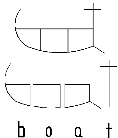
Fig. 2-5 Example of English "BOAT" rebus. Drawn by Bart Torbert.
Unlike the example given of the chicken, the existing ship rebus on stone in Colorado had to be interpreted, rather than being made from scratch. The starting place was the picture itself, which was plainly recognizable as a ship (Fig. 2-6). The next step was the realization that there was more: that the picture was actually formed of alphabetical symbols, and that they might mean something. In order to make sense of the letters, it was necessary to record the entire petroglyph correctly, because an epigrapher, who would not see the petroglyph in its natural setting, would be called upon to decipher the script. He had to be able to translate a word or words from the symbols in the order in which they were carved, whether right to left, left to right, or vertically. Last, and most importantly, the translation had to describe the object pictured or its characteristics.
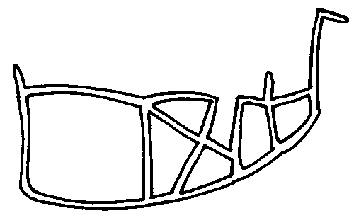
Fig. 2-6 The Rebus Ship petroglyph. Picture Canyon, Colorado.
Here is presented Dr. Barry Fell's decipherment of the ship rebus from Picture Canyon, Colorado. He explained that the ship image is a word in the ancient Berber language, using connected Numidian letters:
"These letters read left to right 'R S B-N'
Modern Arabic 'SAFINA' is 'ship' (Wehr 414). The
sounds of 'B,' 'P,' and 'Ph(F)' constantly
interchange. I know of no other translation of 'R' than
'Re' or 'Ra,' the sun god. The translation is 'Ship
of Ra'"(Fig. 2-7).
Fig. 2-7 Chart of Numidian letters which form Rebus Ship. Transliteration by Fell.
The chance coordination of ancient picture and descriptive
text to form a rebus is quite unlikely. It could not just happen
by accident. The petroglyphs that show such deliberate intertwining
of text and image are hard evidence that the creators of rebus
petroglyphs were very skilled in ancient languages and scripts.
Two more rebuses will be presented in other chapters.
The Simple Ship
An important site exists in LeFlore County, Oklahoma. An outcrop of stone 200 feet long and 50 feet wide is covered with inscriptions which were recorded in 1969. One of these inscriptions, which contained thirty-seven symbols, was translated by Fell. It used Numidian script from North Africa to describe the Battle of Yatrafa. This is discussed in detail in the chapter "They Mourned Their Dead." Thirty more inscriptions, which appear to be in the same alphabet have not yet been translated.
Returning in 1982 to look more closely at a petroglyph shaped like an ingot, which had been recorded but not recognized at the time, it was found that not only was the ingot petroglyph covered with junk, but most of the entire expanse of stone had become a dump ground. On one small expanse of undisturbed stone, there were some broad but shallow lines, too eroded to identify or photograph. In such instances, the lines can sometimes be ascertained by covering the stone with butcher paper and tracing with the blunt end of a jumbo kindergarten crayon, permitting the lines to guide the crayon.
The tracing which emerged was extremely simple, but it could not be denied that it was a ship (Fig. 2-8). A curved sail extended on both sides of a mast. The hull was pointed at one end and squared off at the other.
Fig. 2-8 The Simple Ship petroglyph, LeFlore County, Oklahoma.
Although there are few illustrations of ancient ships
with hulls of this shape, one is found on a Minoan seal, dated
between 1600-1200 B.C.25 This ship has a double sail. Crete, in
the mediterranean Sea, is north of ancient Numidia.
The Geola Ship
A rancher from the Oklahoma Panhandle spoke to my exploring party of some petroglyphs on a cliff "down by the river." He was not able to describe them and could not guide us to them but did point down a nearly non-existent road and said to follow it until we found a spring by the river, near a cliff. We were to watch out for snakes. This was in October 1978.
For several miles we followed a precipitous trail, zig-zagging for the sake of the tires on the four-wheel drive vehicle, until the site was found. It was marked by a large vertical stone that rose above the spring. There was incised a beautiful, graceful ship. It even had lettering on the hull! There was no time that day to make a latex mold, so a careful tracing of the 5-inch petroglyph was made. Eight months later, the little ship by the spring was recorded with photographs and a latex mold (Fig. 2-12).
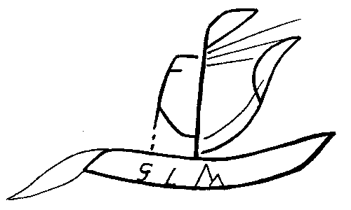
Fig. 2-12 The Gaelic Yawl Petroglyph, Oklahoma Panhandle.
Fell was able to decipher the inscription on the hull of the ship petroglyph. The lettering said "GEOLA," meaning "yawl" in the Gaelic language. The petroglyph ship has two masts. The shorter one is aft, as in a modern yawl. Fell also observed that a pennant is flying from the main mast, and that the ship seems to be dragging a net.
The Ship with the Billowing Sails
So many inscriptions and anthropomorphic figures were on the cliff behind the spring that we actually missed seeing another ship in the fading light. In June 1979 another exploring party properly recorded all that had been seen so hurriedly the year before. Further Celtic evidence was found to provide context for the little yawl. There was also evidence at the site that other cultures had traveled up the same river.
The cameras were clicking, the latex was busily being
applied, when Bart Torbert noticed on a protruding curve of stone
a distinctive design, but one partly spalled away. Our imaginations
filled in the missing lines. And there it was, portrayed by the
natural curve of the stone: a ship with an 18-inch curved hull
with oars, a pointed bow, and sails that seem to billow in the
wind (Figs. 2-14).
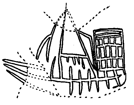
Fig. 2-14 Drawing of Ship with the Billowing Sails petroglyph, Oklahoma Panhandle. Dashed lines show where rock face was spalled.
We traced, photographed, sketched, and doused the image with latex to make a thick mold. Later there was a problem with making a curved plaster cast, solved by laying the latex mold in an wooden oval dough bowl.
At the stern, a checkered sail appeared to be of the sprit-rigged type. There was also a triangular sail and slanted lines representing ropes to steady the mast and control the sail. Most of the features of this ship are echoed in an illustration of a ship on a Minoan seal, dated between 1600-1200 B.C. (Fig. 2-15).
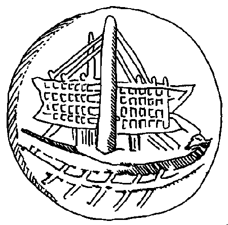
Fig. 2-15 Comparison to Fig. 2-13: Ship from a
Minoan Seal. Redrawn by Roth from Casson.
The Emblem Ship
A certain huge boulder in Baca County, Colorado, is covered with important petroglyphs. The site is reached by traveling through miles of cactus. Fortunately, its isolation has utterly protected it from vandalism. Dale Murphy was the first in our group to notice a ship's image, deeply pecked at ground level (Fig. 2-20). The ship, 22 inches tall and 17 inches wide, had a crescent hull, high prow, mast, high square sail, rope rigging, and some marks on the hull. All of the lines are pecked and appear to be old.
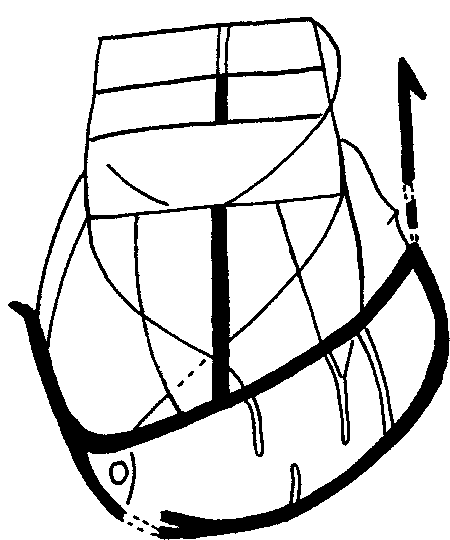
Fig. 2-20 Photograph (left) and drawing (right) of the Emblem Ship petroglyph, Baca County, southeastern Colorado. Photograph by John Shuller.
Properly recorded in 1978 by tracings, photographs, latex mold, and plaster casts, it was later declared by Fell to be "The finest depiction of an ancient ship yet discovered anywhere in America." His own rendering of it, slightly stylized, became the emblem of the Epigraphic Society (Fig. 2-21). The Latin legend says "Out of Epigraphy comes forth History." It decorates the jacket and every chapter heading of his book Saga America, and every Membership and Fellowship Certificate issued after its adoption. He and his colleague, James Whittall, who specializes in Portuguese antiquities, agree that it closely resembles a ship on an ancient Portuguese coin (Fig. 2-22). The coin depicts a ship from Osunoba. This Iberian Celtic word is believed to be the name of the people who lived in the town, rather than the town itself.
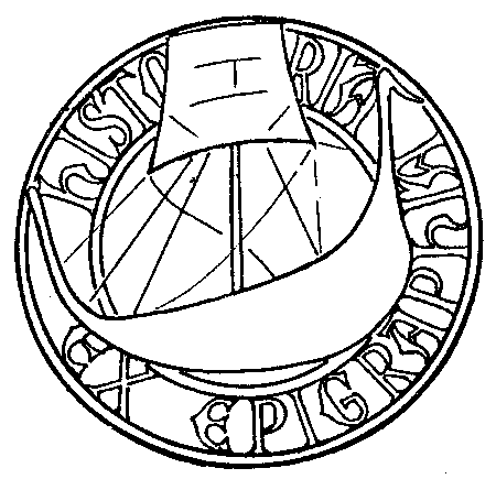
Fig. 2-21 Stylized version of ship in Fig. 2-20
used on Seal of the Epigraphic Society. Drawn by Fell.
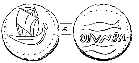
Fig. 2-22 Comparison to Fig. 2-20: A ship from an ancient Portuguese coin. As Published by Fell.
Their opinion is verified by Captain Antonio Domingos Simoes Coelho of Portugal. Coelho is an accomplished man: a graduate of M. I. T. in naval engineering and architecture, author of a book on ancient Portuguese coins, and former professor of numismatics at various Portuguese universities.
Whittall appears in a video tape made in 1989 at the site of the Emblem Ship. He is shown using aluminum water-soluble paint, outlining what he thinks he sees on the stone. Unfortunately, his opinion does not at all agree with the photographs we took, the latex mold I made, or the drawing made from it and published in this chapter. He also says, "Gloria Farley calls this a rebus ship, made of letters." The Rebus Ship is miles away in Picture Canyon, Colorado.
The Ships at Hicklin Springs
The Arkansas River heads in the heights of Colorado as a sparkling narrow stream, and widens as it flows eastward through the plains of the state. If we can judge by one site south of the river, not far from the city of Las Animas, it was a major thoroughfare for ships in ancient times. That site is at Hicklin Springs, which is a great mass of dark broken boulders, some as large as a small house. John Flinn made a photographic study of the site in June 1985, during a rare wet period, and concluded that a stream which no longer exists once flowed from the springs toward the Arkansas River.
According to Flinn, Hicklin Springs was one of the favorite sites of Senator William Coxan of Arizona, who made a great pioneering study of petroglyphs worldwide, but who unfortunately died before much of his work was published. He believed that ancient people traveled around the world, leaving carved stones to mark the way. When Coxan became ill, he offered his vast collection of slides to Flinn. This man, who later regretted that he had accepted only twenty-nine of them, has generously shared them with others. The remainder of the collection has vanished. We can only hope that it is on file at some library or university.
The inscriptions and abundant petroglyphs found at
Hicklin Springs are pecked through the dark patina to the lighter
stone beneath. Some appear to be very ancient. In these the patina
has re-formed to darken the grooves. In four visits to Hicklin
Springs, beginning in 1982, six pecked petroglyphs of ancient
ships have been recorded.
The Ship with the Footprints
Probably the most significant ship petroglyph at Hicklin Springs is contained within a large vertical panel which is reached only through a narrow passageway of stone, and exited through a crawl space. The hidden location has no doubt protected it from vandalism. The ship is surrounded by pecked footprints (Fig. 2-23).
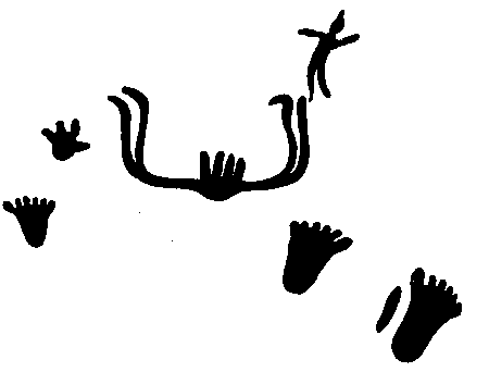
Fig. 2-23 The Ship with Footprints and Figurehead petroglyph, Hicklin Springs, Colorado. As drawn and published by Fell.
Fell's published opinion of a ship on this panel states that it is of Norse origin. It has a high double prow and a high double stern, while in the center rise four vertical marks. Above the right end, presumably the stern, is pecked a human figure with outspread arms. Among other motifs on the panel, including a hand mounted on a pole, are several feet which feature six toes. Fell had compared Bronze Age ship petroglyphs from Peterborough, Ontario, with those found in Sweden (Fig. 2-24). He thinks the human figures represent the Vanir, a family of Norse gods, who hold their hands over the crewmen for protection. Without disputing his opinion, I wish to add that in the wadis between the Nile and the Red Sea there are found Egyptian analogues to the Hicklin Springs figure with outstretched arms and the six-toed feet. One example is found at Hosh, which lies between Edfu and Aswan on the Nile River (Fig. 2-25). Perhaps this additional information may be reconciled with Fell's opinion through his research indicating that there was contact between the Norse and the Egyptians about 1250 B.C.
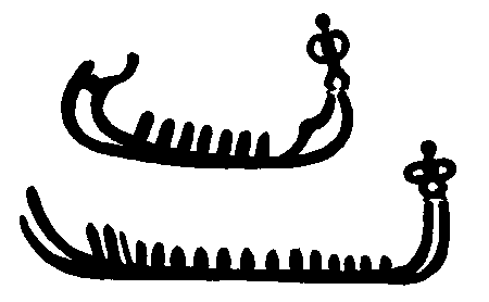
Fig. 2-24 Comparison to 2-23: Petroglyphs of ships, Sweden. As drawn and published by Fell.
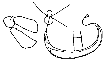
Fig. 2-25 Comparison to Fig. 2-23: Ship petroglyph, Hosh, Egypt. Redrawn from Winkler.
The Trident Ship
Around a stone corner, near the ship with footprints, is another beautiful ship image, 15 inches in length and 14 inches tall, deeply pecked into the dark surface (Fig. 2-26). It features the sharply upturned bow and stern of a Mediterranean ship. A mast supports a square sail, which is divided into seven portions, and connected on the right side to a pole. At the tip of the pole is the most interesting feature of this ship, a plainly pecked trident, symbol of Neptune, god of the sea.
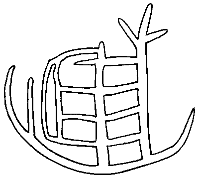
Fig. 2-26 The Trident Ship petroglyph, Hicklin Springs, Colorado.
A reference describes Neptune as, "majestic and middle-aged, with long flowing hair and beard, wearing a seaweed crown, and brandishing a trident, or three-pronged fork." He was widely worshiped through Greece and Italy, and had countless shrines. His principal votaries were the seamen and horse trainers, who often bespoke his aid. He was also called "Poseidon" in Greece.
The Colorado trident ship resembles a ship on a Minoan seal, circa 2000 B.C., which has a trident on the right side at the up-curved bow, a mast and sail divided into sections, and an upright pole at the left (Fig. 2-27). This pole also appears on the Colorado ship.
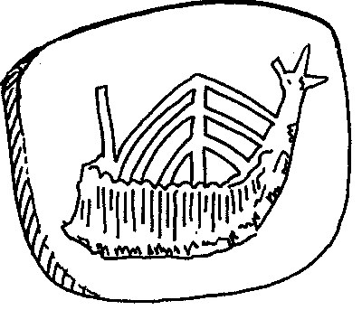
Fig. 2-27 Comparison to Fig. 2-26: Ship on Minoan seal. Redrawn by Roth from Casson.
Another example of a ship with a trident, is on a rock inscription at Karstad, Norway, on the Nord Fjord (Fig. 2-28). It is thought to date from 250 A.D. The inscription by the ship states: "I the foreigner, the Bavarian (scratched the inscription)." Those Mediterranean-style ships did get around!
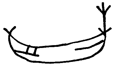
Fig. 2-28 Comparison to Fig. 2-26: Ship petroglyph, Norway. Redrawn from Jensen.
The Galley of the Sun
At the exit of another stone corridor at Hicklin Springs, there was a pecked ship at eye level (Fig. 2-31). It appeared to be a galley, although it was not the usual long-hulled version with multiple banks of oars. This hull was short and rounded, and had a bank of only six oars.
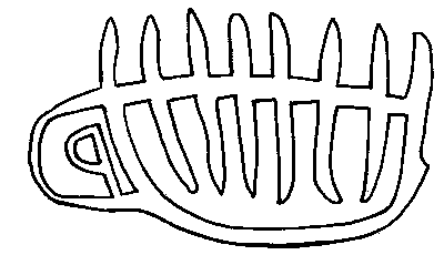
Fig. 2-31 The Galley of the Sun petroglyph, Hicklin Springs, Colorado.
At the left side of this 15-inch petroglyph was its most distinctive feature: a curved enclosure which was level with the line of the deck and continued to the keel. The curved space contained an alphabetical symbol like a backward "P."
Galleys, although usually associated with the Greeks, were also common in ancient Phoenicia. The first recorded trading voyage was made by Phoenicians, in 2650 B.C., when forty ships brought cedar logs to Egypt from Lebanon for Pharaoh Sneferu.
Evidence to confirm the identification of the Hicklin Springs petroglyph as a galley was found in a photograph of a coin from the Phoenician city of Aradus, dated mid-fourth century B.C. (Fig. 2-32). The coin was stamped with a galley which showed the rowers sitting inside the hull, with script above the ship and with waves below. Its rounded short hull ended at the right with a curve forming the same backward "P" that appears on the Colorado galley.
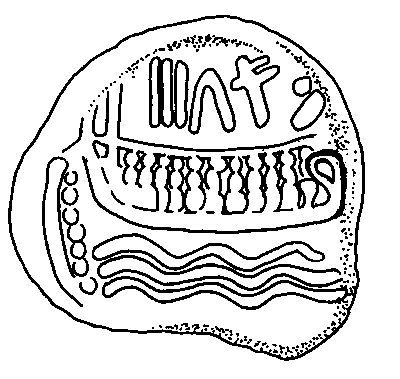
Fig. 2-32 Comparison to Fig. 2-31: A coin showing a galley, Phoenician City of Aradus. Redrawn by Roth from Bass.
In the Phoenician alphabet this backward "P" stands for the letter "R." At sites in Oklahoma and Colorado this symbol is upheld by god-like figures, as discussed in the chapters "The Graven Images" and "An Affinity for Tanit." It probably refers to Ra, the Sun God. Could the Hicklin galley represent a sunship?
The Dragon Ship
A ship petroglyph, made of broad pecked lines, with a dragon head at the prow, is spread over an area of 24 by 22 inches at Hicklin Springs (Fig. 2-33). The petroglyph is near the ground, and a photographer must back up firmly against the opposite stone wall to get the entire image on one frame.
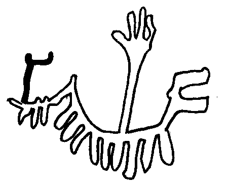
Fig. 2-33 The Dragon Ship Petroglyph, Hicklin Springs, Colorado.
It is only after the lines of pecked dots are redrawn as broad solid lines that the ship pattern emerges. The dragon head, on the right of the image, has an open mouth, a scowling eye, and three sharp projections from its head. Below the long neck is a sharp projection which could be a ram. There is a hull, and a stern ends with the dragon's tail. Below the hull hangs two oars and at the stern seems to be a rudder. The sail is clearly drawn and is attached to a mast. At the top of the sail a circular pennant seems to fly. The clincher is the image of an oval-headed passenger in the back of the boat, standing with upraised arms. The figures on boat images in Sweden, representing a god or goddess with arms raised in protection and blessing have already been discussed. These also occur in Egypt. For comparison is offered a ship petroglyph from Gerf Husrin, which is on the east side of the Nile River south of Aswan (Fig. 2-34). In the stern stands the same oval-headed figure in the same pose. There is also the dragon head and the four-fingered hand on a mast or pole which also appears on the Hicklin Springs panel. The ancient artist in Colorado expressed spirit, action, and verve in his design. He must have worked for many hours sitting cross-legged to leave his record of a ship.
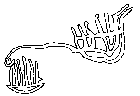
Fig. 2-34 Comparison to Fig. 2-33: Ship petroglyph, Gerf Husrin, Egypt. Redrawn from Feresch.
The Ship of Tarshish
A note with an accompanying sketch was appended at the bottom of a letter from Lyle Underwood of Tucson, Arizona. It said "My ship from Hidgpeth Hills, north of Phoenix. Is this a ship of Tarshish?" His sketch of the ship included two wavy lines like water and an inscription.
After Underwood's untimely death in 1984, his widow gave permission to use his photographs and to quote from an unpublished paper he had written which stated:
"Here we have two wavy lines of ocean upon which sits a two-decked ship with rectangular sail. Backstays for the mast are shown, but no forestays. To the left of the ship we find some abstract symbols. Identified by Dr. Barry Fell as South Iberian Punic, the letters are 'S S-F-N.' The Punic has no 'F' and like the Hebrew, uses a form of 'P' to create the 'F' sound. Modern Arabic does have an F and would have spelled this as 'S S-F-N' which is 'ES SAFN,' or in English 'The Ship.' So we have here a drawing of a ship on a rock and a caption which identifies it as 'The Ship,' there being no question as to the intent of the artist. This inscription has been 'core sampled' by archaeologists who have carelessly allowed the borings to dribble down the face of the rock and dry like cement. Why they did not wash this off while it was still wet is to their eternal shame. Here on the Arizona desert is a pre-Columbian carving of a ship. Evidence pure and simple of perhaps many pre-Columbian voyages, is it to be destroyed?"
A drawing of Underwood's petroglyph is traced from his photographic enlargement, disregarding the lines made by the dribbled core sample cement (Fig. 2-36). The fourth Punic letter is dotted in the illustration, as it is too dim to be seen plainly in the photograph. Apparently Underwood found and sketched the entire petroglyph before the archaeologists' damage was done.
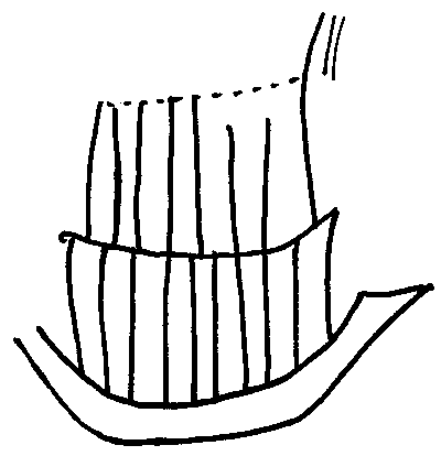
Fig. 2-36 A ship petroglyph, Arizona. Redrawn from photograph by Lyle Underwood.
Underwood's question about a ship of Tarshish refers to Chapter 8 of Fell's book, America B.C. "The ships of Tarshish." Tarshish was a city in southwestern Iberia (modern Spain), called Tartessos by the Greeks, where the largest seagoing vessels known to the Semitic world were made. The image of a ship hull and an inscription written in Tartessian Punic was found on a Rhode Island seashore in 1780. Fell's decipherment of the inscription reads: "Mariners from Tarshish this stone proclaims."
The Trip Back Home
Recently, evidence from Europe has come to light which shows that ancient mariners not only reached North America but that they safely made it back home.54 In the Spring of 1992 scientists found some unusual shells on a beach off northern Denmark. These shells were of an American sea-food favorite, the soft-shell clam (Mya arenaria). These shells were carbon-dated, giving dates as old as 1245 A.D.
Kaj Strand Peterson, of the Geological Survey of Denmark, states that the larvae of the soft-shell clam can not attach itself to another object. This life stage also has only a three week period in which to find a suitable spot in the sand to bury itself, and continue its development. This is too short of a time period to allow the larvae to be carried by ocean currents from North America to Europe.
However, this is plenty of time for the swift Viking ships of the thirteenth century to make the crossing. Peterson believes that the clam larvae were carried across the Atlantic Ocean in the bilge water or on the wet open decks of Vikings vessels. Once the Vikings reached the sandy shores of Denmark, emptying the bilges and cleaning off the deck would have turned the larvae loose into a friendly environment. It is also possible that the Vikings brought mature clams along on their voyage for food, and what was found was the remains of an ancient clam bake.
They Came to America
They traversed the oceans, they sailed up the rivers
of the land which was to become America. They paddled up its creeks,
they settled by the springs. They drank the good water of the
land of abundance. It was so important to them that they left
messages and pictures of their ships and boats on enduring stone
to explain their presence. These were real people, with diverse
skills: individuals with names.